A description of Texas Original Land Owner maps
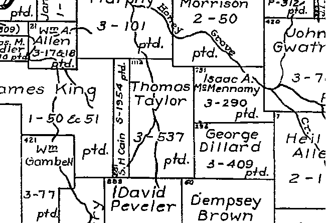
Take a look at this extract from the Fannin County map. This area is
about 5 miles West North West of the town of Honey Grove.
Thomas Taylor was possibly my Great-Great-Great Grand Father. He entered Texas in late 1839, and applied for a land certificate in January 1840 at the Red River County Courthouse. Also signing the certificate book on the same page were others that emmigrated with him from Tennessee. Thomas and other of his relatives then travelled into Texas seeking unclaimed land. Thomas and his father-in-law found their land in Fannin County. Entering Texas before 1840 and being a head of household entitled Thomas to 640 acres. Upon finding his land, Thomas's first chore was to stake out the claim. Afterwards, he would have to obtain a survey (no easy feat in those days), and then file the survey at a nearby courthouse. He would then have to file a formal claim for the land, known as a Land Patent. As you will see, the patent was not awarded until 1886. From inspection of county records, I know that Thomas sold his land in the 1850's to a William M. Williams. This was quite typical - record keeping didn't keep up with events very well! Thomas never lived on this land, or at least never established a residence of any duration.
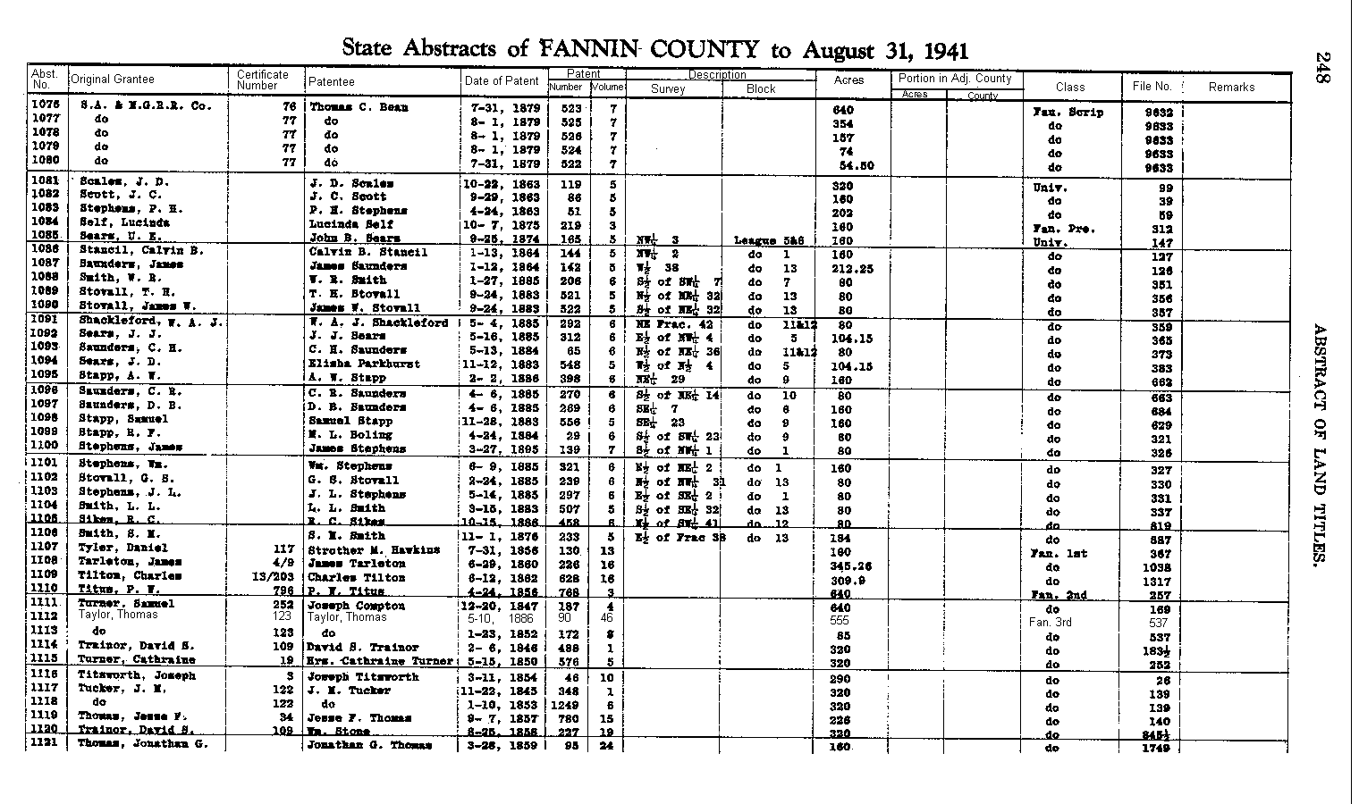
In the early 1900's, the State of Texas General Land Office started formerally compiling records of these original land owners. They published a multi-volume set of Land Abstracts of the Original Land Owners of Texas. Only the first people to own a particular tract of land are in these volumes. Subsequent owners must be derived from local county records. There are about 8 or 10 books in these volumes, with each book being quite thick. These Abstracts are available at the Texas General Land Office in Austin, at many county Title Survey companies, and also at some public libraries. Click here, to see an image of one page taken from the Fannin County Abstracts.
Near the bottom of the page you will find the abstract for the Thomas Taylor track. You will see that it was Abstract No. 1112; Certificate Number 123; that the tract was patented in 10 May 1886; that the tract contained 555 acres; that it was a "Fannin 3rd Class" grant; and that it was recorded in File Number 537. Immediately below that entry you will see that Thomas obtained another tract of land in Fannin County of 85 acres in size. These two tracts amounted to 640 acres, the maximum allowed for Thomas from his certificate obtained in Red River County.
Please be aware that some of the Original Land Owner maps do not show the original land owners name within the track; showing instead just the type of grant, and the file number. Hence, it may be necessary to obtain a copy of the Land Abstracts to find the abstract number or the file number in order to locate a tract on a map. Reference this extract from Borden County as an example.
The Texas General Land Office also has on file all legal documents that pertain in any way to these original land owner tracts. Certificate application, survey descriptions, probate records, legal briefs, to name just a few. The date on the Certificate Application will most usually closely correspond to a persons date of entry into Texas and will infer others that may have been in the same travelling party. The father-in-law of Thomas Taylor died in later 1840. Thomas was appointed executor of the estate and many, many documents were found pertaining to the disposition of his father-in-laws land. Given the Abstract information, these documents can be found and copies obtain from the General Land Office for a small fee. These documents can be a Genealogist's dream come true!
The maps are also invaluable as a means to locate exactly where one homesteaded and, in many cases, relatives can be found living nearby.